Layers like that can be observed in modern sand dunes.
One stacked on top of each other? And then lithified ( you see cracks across the lithified layers).
That’s a lot of orange sand and white sand. So are you saying the wind was blowing that strong and then sorted out multiple layers at once or one layer at a time. Was the wind current steady, and for how long?
Look at it again. You want to stick with your wind aero-sorting theory acting over how many years to make multiple layers.
You’ve not offered proof of you claims for something of that scale, just assertions, not to mention the post-lithification cracks that obvsiously suggest a sequence of events to boot that you haven’t reconciled with your wind theory.
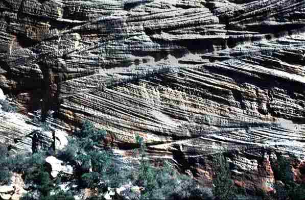
For the interested, here is a description of the above formation:
The Wave is a sandstone rock formation located in Arizona, United States, near its northern border with Utah. The formation is situated on the slopes of the Coyote Buttes in the Paria Canyon-Vermilion Cliffs Wilderness of the Colorado Plateau. The area is administered by the Bureau of Land Management (BLM) at the Grand Staircase-Escalante National Monument visitor center in Kanab, Utah.
The Wave consists of intersecting U-shaped troughs that have been eroded into Navajo Sandstone of Jurassic age. The two major troughs which comprise this rock formation are 62 feet (19 m) wide by 118 feet (36 m) long and 7 feet (2 m) wide by 52 feet (16 m) long. Initially, infrequent runoff eroded these troughs along joints within the Navajo Sandstone. After their formation, the drainage basin, which fed rainwater to these troughs, shrank to the point that the runoff became insufficient to contribute to the cutting of these troughs. As a result, the troughs are now almost exclusively eroded by wind, as indicated by the orientation of erosional steps and risers cut into the sandstone along their steep walls. These erosional steps and risers are oriented relative to the predominant direction of the wind as it is now naturally funneled into and through these troughs.
The Wave exposes large-scale sets of cross-bedded eolian sandstone composed of rhythmic and cyclic alternating grainflow and windripple laminae. The rhythmic and cyclic alternating laminae represent periodic changes in the prevailing winds during the Jurassic period as large sand dunes migrated across a sandy desert. The thin ridges and ribbing seen within the Wave are the result of the differential erosion of rhythmic and cyclic alternating grainflow and windripple laminae within the Navajo Sandstone. These laminae have differing resistance to erosion as they have been differentially cemented according to variations in the grain size of the sand composing them. The soft sandstone is fragile, especially the ridges and ribbing of the Wave. As a result, visitors must walk carefully to avoid breaking the small ridges.
In some areas the Wave exposes deformed laminae within the Navajo Sandstone. These laminae were deformed prior to the lithification of the sand to form sandstone. Judging from their physical characteristics, this deformation likely represents the trampling and churning of these sands by dinosaurs after their deposition. Dinosaur tracks and the fossil burrows of desert-dwelling arthropods, such as beetles and other insects, have been found in the Navajo Sandstone within the North Coyote Buttes Wilderness Area.
The Navajo Sandstone is now actively being studied by YEC geologists. Prior to that, the Coconino sandstone was studied to refute the wind-formation hypothesis. It might be informative to see the evaluation of the chair of the geology department of Cedarville, John Whitmore on the wind-theory of Coconino.
I was at ICC 2018 when Dr. Whitmore presented the findings of this paper:
The Permian Coconino Sandstone is one of the most prominent layers of rock in the Grand Canyon and is important to creationists because it has often been used by conventional scientists to discredit the Bible since it is a supposed windblown (eolian) deposit. Their argument is that deposits like this would be impossible to form in the midst of a global flood as described in Genesis. Over the past forty years, new data has been collected by us and others that we believe indisputably identifies the Coconino as a subaqueous sandstone–data that will be difficult for our critics to counter. These data include evidence from petrology, fossil footprint studies, sedimentology, regional stratigraphy and soft sediment deformation features. In our studies we found that there are many misconceptions or “urban myths” about the Coconino Sandstone including its grain roundness, grain sorting, grain frosting and angle of cross-bed dips. There are no modern analogs that match the precise sedimentology of the Coconino, but we believe that subaqueous sand waves may be a start in the right direction to understand how the Coconino was deposited. Instead of the Coconino being a problem for creationists, it can be one of our most powerful arguments in support of the biblical account of the Flood. There are many other similar cross-bedded sandstones around the world; the Coconino may be the key to unlocking their origin as well.
…
Edwin McKee published
the first and, until our studies, the only comprehensive study of
the sandstone in 1934. He concluded then and in his later works
(1979) that the Coconino was wind-blown. Many Pennsylvanian and Permian sandstones very similar to the Coconino occur around the world and this fact is often used as compelling evidence that Pangea was a subaerial supercontinent. At various times for about the last forty years some significant new discoveries have been made about the Coconino. This report is a summary of that work and what we currently understand about the Coconino. Even though more work remains to be done and all of the answers are not yet clear, we believe the evidence now undeniably suggests a subaqueous origin for this important sandstone
You mean YEC “geologists” are actively trying to think of new lame excuses to ignore all of modern geology and pass on YEC lies to the True Believers. Same as it ever was.
You don’t even read what I write. Again, these layers are seen in modern sand dunes. The orange is iron staining. The white is an absence of iron staining. It’s diagenetic, not original.
Lots of photos, maps, geology of the surrounding area, etc. Turns out there are actually two “wave” formations about a half mile apart. There are also lots of other neat things like lots of dinosaur tracks and natural bridges/arches.
First thing you really need to get your head around is that those curved layers only appear to be curved because they have been cut by erosion. Imagine a dipping flat layer, and intersect it with a U-shaped channel. The line of intersection will be U-shaped even though the layer is planar.
Having said that, dune forsets often can have some curvature, I think that is visible in the lower part of the exposure at the back of the picture. The curves in the foreground are only apparent.
You also need to understand that modern day desert dunes do look exactly like that if you were to slice through them vertically. They migrate because the wind picks up sand from the wind side, moves it over the crest, and then deposits it on the leeside. This goes on all the time, and if you were to sit on a real-life desert dune you will actually see (and feel) the sand grains moving like that. This process causes the layers.
Most deserts have one prevailing wind direction (because they lie in the zones of the trade winds), and the foresets are generally aligned with that. Sometimes the direction changes and that will be reflected in the orientation of the foresets.
Here is another question: if such sands are marine, then why are there practically no fossils in them, unlike virtually all other marine sandstones we know of? Why are they not full of microfossils? On the other hand, would you expect to find many fossils in ancient desert sands?
I asked you a question about a month ago re the Premian Basin, right before you took a break:
“So, how did all of this faulting, syndepositional facies formation, more faulting, end of faulting and the over draping of 8,000 feet of more rocks happen in one Floody year?”
Before you Gallop again, will you give me the honor of a straight answer?
Maybe in future, if you don’t have an answer to someone’s question, you could actually reply with “I don’t know” instead of silently moving on to another point. At least that way people don’t get the impression they’re being ignored.
I’ll do that if I see what they said, but I actually did respond to SuperCritical, and I said earlier I don’t have answers. I didn’t appreciate his insult.
John Harshman on the other hand made it easy since he’s asserting air can create the layers in the Navajo sandstone examples cited.
There are mechanistic problems with this not to mention evidential ones. John however is not so quick to acknowledge an indefensible position that as pointed out by Dr. Whitmore is mostly and Urban myth perpetuated in professional literature.
Again, exactly this sort of thing is seen in modern sand dunes. Are you saying that modern sand dunes were produced by a worldwide flood? Tell me, is a professor at an institution that demands a YEC interpretation of all data a reliable guide to geology? John, on the other hand, has no indefensible position. John knows some geology and recognizes cross-bedded sandstone when he sees it.
If you don’t want people to accuse you of the Gish Gallop, there’s a simple solution: don’t Gish Gallop. It’s not an insult if it’s true.
You already ignore everyone who points out your woeful ignorance of geology basics, which is virtually everyone. If your knowledge was 1/100 the size of your ego you would have a roomful of Nobel Prizes by now.